The Accidental Cartographer:
Morgans Street Directory (1917–1976)
writer Stephen Banham published Eye Journal 94 (2017) and the Automotive Historians Association of Australia Journal (2017)
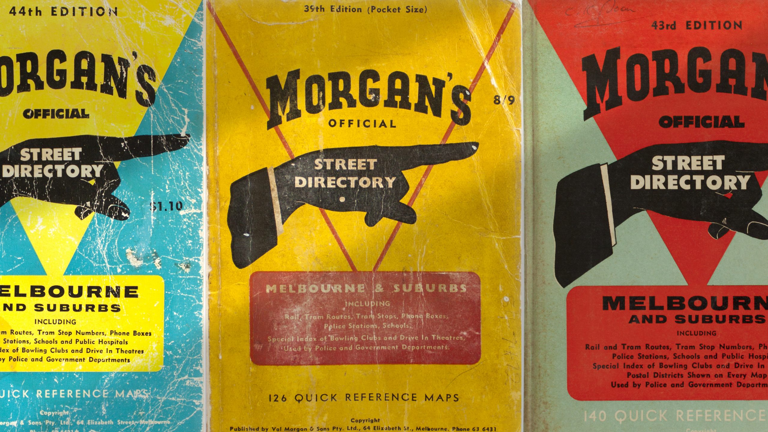
As one of Melbourne’s first noted publicists, Valentine Morgan (1876–1952) was well versed in the powerfully seductive possibilities of the printed image. His print advertising used all the typographic hallmarks of the early advertising age – embellished lettering, unapologetically loud display faces, snappy headlines and of course a typographic device commonly found in any compositors tray of the time – the ‘pointing finger’ known as the ‘index’ or ‘printers fist’.
Used to quite literally point readers eye to a key message, this ‘pointing finger’ motif offered the strategic Morgan an opportunity to perform a clever secondary role – for the covers of the new Morgans Street Directory the pointing finger device offered a perfect dual reading – communicating a way-finding system (the primary function of a map directory) as well as boldly identifying a directory with considerable advertising potential (the primary intent of the directory).
Morgan’s purchase of the Moulton Street Directory business, which had failed after its only edition in 1916, proved to be an astute and well-timed move. In the newly motorised streetscape of 1917 Melbourne, its emergence of the new Morgans Street Directory responded to a public need to know what lay beyond that which was within walking distance. As early as 1922 Val Morgan anticipating his future cinema advertising empire by producing glass slides advertising the modernity and utility of his directory. Press Ads in The Argus boldly stated ‘80 Picture Theatres nightly are telling the public about Morgans Street Directory –New Issue, Revised and Up to Date. On sale at all booksellers. It has a blue cover and fits easily in the pocket’.1
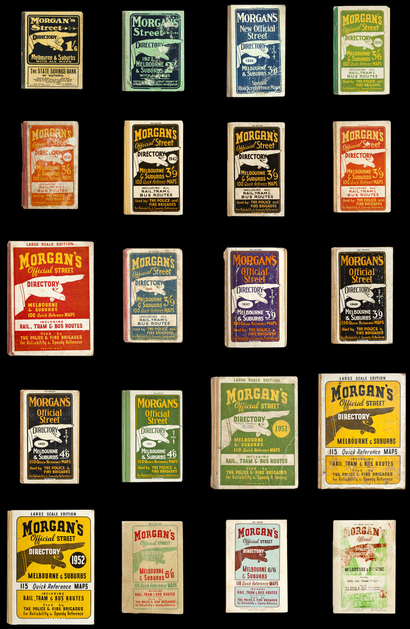
Early Morgans directory covers feature an illustrated hand with somewhat grotesque, gnarled and long-nailed pointing finger, more akin to ‘nosferatu’2 than the intended gentele aspiration. By the 1960s the pointing hand has been streamlined to a simpler black silhouette. Although the hand is presented as slender and elegant, its male gender is made evident by the profile of a neat suit sleeve.
And the title lettering steadily evolves over the sixty issues, it is the pointing hand that remains the emblematic and striking identity design for Morgans.
Whereas earlier cartographers fearing the unknown, and therefore empty, spaces on the outer fringes of their maps, would declare the now renown warning for potential explorers ‘Here be dragons’,3 for Morgan every blank space in the Morgans Street Directory maps represented an advertising opportunity – or ‘Here be profits’.
This strategy proved however to have an ironic fate. As an ever-expanding Melbourne was transforming open country into new residential or industrial estates, the maps within the directory had to change accordingly. Previously blank (rural) areas on the maps that had once been used for advertising were beginning to fill up with new estates and streets. So as Melbourne grew, advertising had to be steadily moved from inside the maps to the frames around its borders and even to the front cover itself. Map 21 of the 44th edition (c.1960) shows a substantial advertisement for a plaster board company over the outlying streets of Edithvale (then a new housing area) whilst a significant proportion of the aqua-coloured mass representing Port Philip Bay is occupied by an advertisement for a local real estate auctioneer. By issue 52 (c.1968) this same geographic area and map page has changed, the advertising (for a home loan company) having been moved overleaf, instead occupying an entire page.
Morgan’s use of a mapping system as a vehicle for commercial gain gently anticipates one of the most current and ubiquitous mapping endeavours – Google Maps. Despite one being local and the other global in its reach, both present themselves as ‘the’ important public reference of their times, blurring the difference between civic and mercantile intention.4 The presence of advertising on the map pages of Morgans – framed around the informational content – appears oddly familiar to website viewers today in a process marketers call ‘skinning’ or ‘page takeover’ whereby all areas around the information content are given over to the raising of advertising revenue. Interestingly, this process is also known in the advertising industry as a ‘roadblock’,5 a term imbued with a fittingly cartographic complexion.
Compared to many of his other entrepenurial ventures, such as his failed attempt to advertise messages on spinning car wheel hubs, the directory did in fact turn a profit. “We were not booksellers and therefore we didn’t really understand the trade. But the Morgan directory was very much a sideline and the job putting out a new edition was periodic. It wasn’t a major money-spinner but it was definitely profitable. As long as the sale price covered the printing, our profit was in the advertising’.6 The confidence of the post-war building boom meant that a new directory had to be published every year or 18 months. To ensure the directory kept pace with the city’s development, the directory’s draftsman, Alf Yorston, would visit councils and learn of new sub-divisions and new streets amending his meticulous maps and drawing new ones.7
The directory soon became a popular and reliable point of reference, and not just by the public. As proclaimed on its earlier covers, Morgans was ‘used by the police and fire brigades for reliability and rapid location’. It was often quoted in the popular newspaper columns of the day as an important reference for getting around the city and suburbs.4 In fact the currency of the directory was so high that some newspaper articles reported them even being stolen from police cars.8
When viewed alongside its counterparts in other Australian cities, the pages of the Morgans Directory were well covered in advertisements, mainly from local estate agents hungry for a market presence throughout the new, burgeoning Melbourne suburbs.
As Valentine Charles Morgan, grandson of the founder, recalls “Every time a new street directory was about to come out you would have to go back to the people who had previously advertised and convince them that they should be in the new book…. It (the directory) was sold cheaply but was a profitable venture because of the inclusion of a large number of advertisements…”.9 The business model was one developed on the run “We… didn’t allow the booksellers a very big margin so they didn’t market them as hard as they might have. Our policy on margins was based on the fast turnover the bookseller benefitted from, for by any standards our book was a ‘best seller’, particularly when compared with other publications of all descriptions on sale. We were not booksellers and therefore didn’t really understand the trade”.10 Despite this apparent naivety, at its height it is said to have held 90% of the market, with only minimal competition from Collins, Sands and McDougall and Universal Business Directories (UBD).11
“The first directory was a small (3 x 5 inch) hardcover book of 320 pages with what seem like rudimentary maps and indexes to government services, associations and societies, cemeteries, asylums and hospitals. This format was first overhauled in 1931 when a larger size book with the now familiar grid index system was used.”12 Describing itself as the ‘Official Street Directory of Melbourne and Suburbs’, the introductory page would proudly announce any revisions that has been made since the last edition ‘In accordance with our policy in providing an adequate coverage of the ever increasing spread of Melbourne suburbs, approximately 2000 new streets have been incorporated into this addition… as a result we have been able to include a greatly expanded area’ 13 as well as acknowledging its following of international convention ‘Following overseas practice, the street index appears at the rear of the directory following the map section’.14
By the mid 1930s the content within the Morgans directory had expanded to include the civic resources as well as the cartographic information. In a description of the new Morgans directory for 1936, The Argus points out that ‘it contains a list of all justices of the peace in the City of Melbourne, an index to all buildings in the city, commissioners of the Supreme Court for taking affidavits, a scale of costs for transfers and mortgages, the distance of the suburb from the city and how to reach them, an index of streets and maps showing their locality’.15
One of the devices to keep print costs lower was to use the same printing plates, changing only the colours from year to year. The unintended result of this is that each issue of Morgans would annually reinforce ‘the brand’, creating one of its most enduring appeals today – an extraordinarily consistent visual identity. Unlike the highly engineered and style-guided corporate identities of today, the consistency of the Morgans brand emerged from thrifty economy rather than any conscious overarching strategy. Throughout some periods of the directory, many issues would be the exactly the same cover as the previous year with only details such as the date and price overprinted in a single colour. Many issues have no dates marked at all. Considered by its makers as a mere side-line to the Val Morgan cinema advertising empire, the directory content of later issues was only lightly updated from year to year. That was of course until a new competitor arrived.
“In the mid 60s the first Melways Street Directory was published. The Melways was an excellent publication and from the first issue we realised that we had a major problem. I had collected and studied street directories from all over the world and was convinced that our book was the best. Unfortunately now it was second best.”16 Morgan’s response was to approach the co-proprietor of Melways, a meticulous cartographer by the name of Merv Godfrey, with an offer to purchase his business. This was declined and so in the late 1960s Morgans had every map of their directory redrawn and a new format was adopted. “Melways had a lot more information than our directory and it had a much larger coverage. I had always regarded our book as ‘Melbourne and Suburbs’ whereas Melways was far more expansive and covered the Mornington Peninsula, Geelong, Bendigo, Ballarat and so on”.17
For Morgans the impact of this superior competitor was relatively swift. “Prior to Melways our best circulation was 80,000 copies, but it started to decline and gradually the cost of printing became prohibitive because of the reduced print run. With great regret we made a commercial decision and ceased publication in 1976”.18
In the decades since its first edition in 1966, the enduring presence of the Melways cemented into Melbourne culture in a way that Morgans had not. The design of a Melways directory is so distinctive that artists and designers have reflected it in a ‘variety of teapots, mugs, cushion covers, T-shirts, clocks, coasters, placemats, jewellery and wrapping paper sporting the maps’.19 Its real point of distinction came from its masterfully drawn maps, redefining the cartographic conventions of the time such as ‘their use of single line representations of roads… It was thought at the time to be a mistake, however the design was popular with the users, the driving public, and this design became the ‘new’ convention’.20
Compared to its successor, Melways, cartographic prowess was never the strength or intention of the Morgans directory. Instead its innovations lay in the development of a distinctive and cohesive visual identity (the clever dual reading of the printers fist as an enduring brand) as well as the revenue system through which advertising could be integrated throughout the directory lay the way for future directories, such as Melways, to then develop further as a viable business model.
Perhaps the most telling record of the directory’s public appeal took the form of the Argus’ obituary of Val Morgan in 1952, when the Morgans directory stood unchallenged. Although by this time cinema advertising constituted the vast majority of Morgans’ business empire, the obituary ultimately referred to his earlier contribution, describing him as ‘the man behind the famous Morgan’s Street Directory that has solved the problems of Melbourne visitors for years’, 21 perhaps an appropriate and final acknowledgement of Morgan as the ‘accidental cartographer’.
1. The Argus, 21 September 1922, 13.
2. Nosferatu is the main character in the German Expressionist horror film Nosferatu, eine Symphonie des Grauens (1922) directed by F.W. Murnau.
3. The existence or otherwise of the words Hic sunt dracones (Latin) or “Here be dragons” on ancient European maps is still debated by cartographic historians. Some argue that it does not exist on any paper map but rather only on one of the very first atlas globes, the Hunt-Lenox Globe (c.1510).
4. According to the Google’s quarterly report from 30 September 2016, (http://www.investopedia.com/articles/investing/061115/ how-does-google-maps-makes-money.asp#ixzz4TuXPcCou) Google websites generates over 70% of Google Revenues and includes AdWords revenue from Google.com, as well as advertising revenue generated from YouTube, Gmail, Maps, Finance, Google Play, etc.
5. https://theonlineadvertisingguide.com/glossary/roadblock-ad/ (accessed 26 December 2018).
6. Healy, Chris. Interview with Valentine Charles Morgan (grandson of founder), Melbourne University. 22 April 1994.
7. Golding, Peter.‘What goes on’, The Argus, Wednesday 27 October 1957, 5.
8. ‘They stole from a police car!’, The Argus, 13 October 1956, 19.
9. Healy, Chris. Interview with Valentine Charles Morgan (grandson of founder), Melbourne University. 22 April 1994.
10. Ibid.
11. Ibid.
12. Ibid.
13. Morgans Street Directory, 39th Edition, pocket size. Introductory Page.
14. Ibid.
15. The Argus, Wednesday 29 January 1936, 15
16. Healy, Chris. Interview with Valentine Charles Morgan (grandson of founder), Melbourne University. 22 April 1994.
17. Ibid.
18. Ibid.
19. Stevens, Andrew. ‘The Melways is turning 50. But will Melbourne’s back-seat bible survive the GPS?’ The Age, 15 April 2015
20. Jelfs, Laura. Cartwright, William. Pupedis,Gita. ‘Considering innovations in cartography and changes in geographic representation methods’, Geospatial Science Research 3, RMIT University December 2014
21. Advertising Man Dies, The Argus, 12 July 1952, 11.